
Search
The Renewable Energy site for Do-It-Yourselfers
Do You Have Enough Wind to Run A
Windmill?
The "Wind
Resource Atlas of the United States" will give you a rough idea if your area
has wind potential.
Here is how to use it.
Find the Wind Map for Your
State:
This section provides maps of each
state -- look down the list of links to find the wind map for your state:
http://rredc.nrel.gov/wind/pubs/atlas/maps.html#2-1
Here is a sample for Montana:

From the map for your state, find out
what Wind Class your area is in. The Wind Classes are numbered from 1 to 7
-- the table below from the Wind Atlas gives the definition for each wind class.
The paragraph below tells you what the wind potential is for each Wind Class.
"The wind resource maps estimate
the resource in terms of wind power classes
(Table 1-1),
ranging from class 1 (the lowest) to class 7 (the highest). Each class
represents a range of mean wind power density (in units of W/m2) or
equivalent mean wind speed at the specified height(s) above ground. Areas
designated class 3 or greater are suitable for most wind turbine
applications, whereas class 2 areas are marginal. Class 1 areas
are generally not suitable, although a few locations (e.g., exposed
hilltops not shown on the maps) with adequate wind resource for wind turbine
applications may exist in some class I areas."
Even if you are in a class 3 or above
area, you will still need to do an assessment of your site to see if it will
work, but at least you know there is some potential.
Table 1-1 Classes of wind power
density at 10 m and 50 m(a)
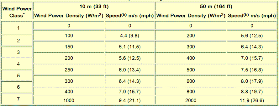
(a) Vertical extrapolation of wind speed based on the 1/7 power law.
(b) Mean wind speed is based on Rayleigh speed distribution of equivalent
mean wind power density. Wind speed is for standard sea-level conditions. To
maintain the same power density, speed increases 3%/1000 m (5%/5000 ft)
elevation.
http://rredc.nrel.gov