Soil Temperature
Soil temperature varies from month to month as a
function of incident solar radiation, rainfall, seasonal swings in overlying air
temperature, local vegetation cover, type of soil, and depth in the earth. Due
to the much higher heat capacity of soil relative to air and the thermal
insulation provided by vegetation and surface soil layers, seasonal changes in
soil temperature deep in the ground are much less than and lag significantly
behind seasonal changes in overlying air temperature. Thus in spring, the soil
naturally warms more slowly and to a lesser extent than the air, and by summer,
it has become cooler than the overlying air and is a natural sink for removing
heat from a building. Likewise in autumn, the soil cools more slowly and to a
lesser extent than the air, and by winter it is warmer than the overlying air
and a natural source for adding heat to a building.
At soil depths greater than 30 feet below the
surface, the soil temperature is relatively constant, and corresponds roughly to
the water temperature measured in groundwater wells 30 to 50 feet deep. This is
referred to as the “mean earth temperature.” Figure 2 shows the mean earth
temperature contours across the United States. In Virginia, the mean earth
temperature ranges from 52ºF in the northern Shenandoah Valley and Winchester
area to 62ºF in coastal Tidewater.
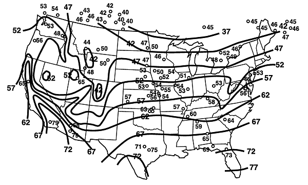
Figure 2. Mean annual earth temperature observations at individual
stations, superimposed on well-water temperature contours.
The amplitude of seasonal changes in soil
temperature on either side of the mean earth temperature depends on the type of
soil and depth below the ground surface. In Virginia the amplitude of soil
temperature change at the ground surface is typically in the range of 20-25ºF,
depending on the extent and type of vegetation cover. At depths greater than
about 30 feet below the surface, however, the soil temperature remains
relatively constant throughout the year, as shown in Figure 3, below.
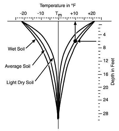
Figure 3. Amplitude of seasonal soil temperature change as a function
of depth below ground surface.
Vertical closed-loop earth heat exchangers are
installed in boreholes 200 to 300 feet deep, where seasonal changes in soil
temperature are completely damped out. Well-based open-loop systems also extend
to this depth or deeper. These ground loop configurations are thus exposed to a
constant year-round temperature.
On the other hand, horizontal-loop, spiral-loop,
and horizontal direct-expansion (DX) loops are installed in trenches that
usually are less than 10 feet deep. For these types of ground loops, it is
important to accurately know the expected seasonal changes in the surrounding
soil temperature. The extra cost of installing such systems in deeper trenches
may be outweighed by the gain in thermal performance, since deeper soils have
less pronounced seasonal temperature changes and are thus closer to room
temperature, which reduces the work load of the heat pump units.
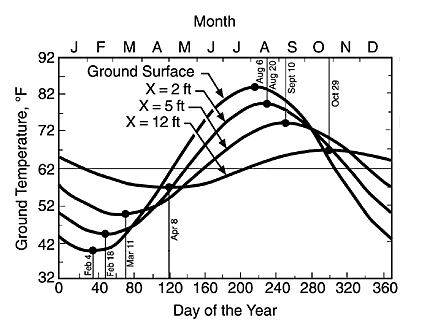
Figure 4. Seasonal soil temperature change as a function of depth below
ground surface for an average moist soil.
Deeper soils not only experience less extreme
seasonal variations in temperature, but the changes that do occur lag farther
behind those of shallower soils. This shifts the soil temperature profile later
in the year, such that it more closely matches the demand for heating and
cooling. Referring to Figure 4 for example, the maximum soil temperature occurs
in late August (when cooling demand is high) at a depth of 5 feet below the
ground surface, but occurs in late October (after the heating season has begun)
at a depth of 12 feet below the surface.
Thus a deeper ground loop installation would lower
the annual operating cost for electrical energy to run the heat pumps, and over
the life of a GHP system, these accumulated savings may more than offset the
higher capital cost of burying the ground loop more deeply. In order to
determine the optimal depth of burial, it is important to accurately know how
the seasonal change in soil temperature varies with depth, which is mainly
determined by the soil's thermal properties.
Soil Thermal Properties
Heat capacity (also known as
specific heat) indicates the ability of a substance to store heat energy; the
greater its heat capacity, the more heat it can gain (or lose) per unit rise (or
fall) in temperature. The heat capacity of dry soil is about 0.20 BTU per pound
per ºF of temperature change, which is only one-fifth the heat capacity of
water. Therefore, moist or saturated soils have greater heat capacities,
typically in the range of 0.23 to 0.25 BTU/lb/ºF. As shown in Figure 3 above,
light dry soils experience greater seasonal temperature swings at a given depth
than wet soils. This is because their lower heat capacity causes their
temperature to rise or fall more than wet soils for a given amount of heat
energy gained in the spring or lost in the fall.
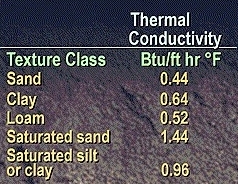
Figure 5. Thermal conductivity of different soil types.
Thermal conductivity is
another soil property that must be known in order to design a closed-loop or
direct expansion GHP system. This indicates the rate at which heat will be
transferred between the ground loop and the surrounding soil for a given
temperature gradient. The thermal conductivity of the soil and rock is the
critical value that determines the length of pipe required, which in turn
affects the installation cost as well as the energy requirements for pumping
working fluid through the ground loop.
Figure 5 indicates the thermal conductivity of
different soil types. Heat transfer capability tends to increase as soil
texture becomes increasingly
fine, with loam mixtures having an intermediate value between sand and clay. As
also shown in this figure, the thermal conductivity of any soil greatly improves
if the soil is saturated with water. This effect is much greater for sandy soils
than for clay or silt, since coarse soils are more porous and therefore hold
more water when wet. Therefore, groundwater
level is another important site
factor in evaluating a potential GHP project and optimizing the depth at which
horizontal and spiral ground loops should be installed.
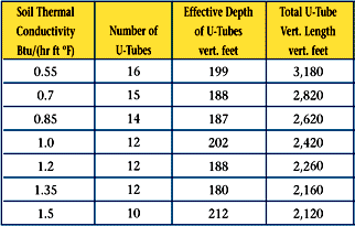
Figure 6. Thermal conductivity influence on number of boreholes and
total length of the earth-coupled heat exchanger per 10 tons of load for
a vertical closed-loop GHP system.
As shown in Figure 6, soil thermal conductivity has
a significant impact on the size of the earth-coupled heat exchanger. Thus in
sandy soils for example (compare dry and saturated thermal conductivities of
Figure 5 with tabulated values in Figure 6), the required length of the ground
loop could be as low as 200 feet per system ton if the soil is saturated with
water, or as high as 300 feet per ton if the soil is dry.
Soil thermal conductivity is of even greater
importance to DX systems and designers might consider the deployment of a
“soaker hose” for horizontal DX ground loops in dry areas or if the project site
is higher than the sounding terrain.
The maps presented in the next section below enable
rough estimates of soil properties for regional screening purposes, but any sort
of detailed feasbility assessment or design study should engage a contractor for in-situ soil
thermal conductivity testing. As shown in Figure 6, the range in ground loop
lengths over the typcial range of soil thermal conductivities is 200 to 300 feet
per system ton, which translates into a 30-50% difference in required land area,
and a 10-20% difference in total system capital cost. In-situ conductivity
testing minimizes the uncertainty in estimating this key thermal property and
avoids undersizing or oversizing the ground loop.
Site Geology
Soil texture
As noted earlier, the thermal conductivity of dry
soils tends to increase as their texture becomes increasingly fine. This simply
is a consequence of the fact that the thermal conductivity of air is about one
hundred times less than that of solid soil particles. Finer soils have more
particle-to-particle contact and smaller insulating air gaps between particles
than coarse soils, hence increased conductivity. The opposite is true for soils
saturated with water, when the pore spaces between particles is filled with
water rather than air, since the thermal conductivity of water is about two to
three times greater than that of solid soil particles.
As a preliminary indication of likely soil texture
at a potential GHP project site, Figure 7 (being developed at USDA) provides a
soils map of Virginia that identifies general regions where various texture
classes are to be found. Within a given region, however, the detailed
distribution of soil textures can vary significantly from the regional norm,
particularly in heavily built areas with a long history of construction
activity. This map should not be used for project feasibility assessment or
design, but is intended to provide rough guidance for preliminary screening.
Groundwater level
As already noted above, the extent to which the
soil is routinely saturated with water greatly influence a soil's thermal
properties and the selection and design of an appropriate ground loop. Figure 8
shows the extent to which the elevation of the groundwater table can vary from
month to month, and from a dry year to a wet year, at selected locations around
Virginia. With this temporal variability in mind, Figure 9 (being developed at
USDA) provides a map of the climatic normal pattern of state groundwater levels.
As with the soil texture map, this should be used for regional guidance only,
and not feasibility assessment or design.
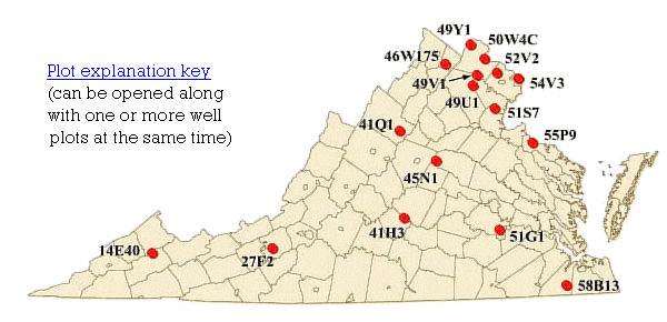
Figure 8. Seasonal and climatic variability of groundwater levels
across Virginia (click on red circle in above map to display data plot
for that well).
Depth to bedrock
Finally, depth to bedrock (i.e., the
thickness of the soil layer) is an important factor that affects the feasibility
of certain ground loop configurations. As explained on the Ground
Loops page, standing column
wells are only possible where bedrock is close to the surface, whereas vertical
closed-loop systems require a depth to bedrock of at least 200 to 400 feet,
depending on the texture and moisture content of the overlying soil. Figure 10
(being developed at USDA) provides a contour map showing the general depth of
bedrock below the ground surface at the regional scale throughout Virginia. Like
the other maps on this page, this is provided to aid in the use of our
preliminary screening tool and should not be substituted for appropriate site
surveys.
