
Search
The Renewable Energy site for Do-It-Yourselfers
Evaluating Your Site For Solar Energy
|
There are two basic questions to answer to determine
if
solar can work well at your location:
-
Does your location get enough sun?
-
Do nearby obstacles (trees, buildings, etc.,) at your
location block too much sun?
The first question depends on how cloudy your
weather is. Within the US, almost all locations get
enough sun to successfully use solar energy, but some are better than others.
This one page solar resources map gives a
rough idea of how good the solar resource is in your area. More detailed
month by month information on the
sun
available at US cities.
The 2nd question is the subject of the next section.
Its critically important that you through this site survey to make sure that you
actually get good sun on your collectors enough of the day and enough to get
good results.
Doing the survey is also a lot of fun!
A great family activity to learn more about the sun's movement through
the sky.
Site Obstacle Survey
Not surprisingly, the sun must actually shine on a
solar collector in order for it to collect useful energy. More
surprisingly, some solar projects are built that never meet expectations because
obstacles block the sun.
Even if you think you get good sun, do the survey. You may find some surprises (I did).
|
|
Path of Sun Across the Sky
Note: If you never liked "Science Time", you may want to skip the next
few paragraphs, and go right to "Obstacle Survey".
The path of the sun across the sky changes with the time of year.
This is why its important to do this obstacle survey, and not just stick your
head out the
window and see what the sun is shining on today.
At the two equinoxes, the sun rises due east and sets due
west. At solar noon on the equinoxes, the altitude of the sun is 90 minus the local
latitude. For example, if you live in Denver with a latitude of 40
degrees, the altitude of the sun at noon on the equinoxes will be 90 - 40 = 50
deg. The length of the day on the equinox everywhere on the earth is
12 hours. The spring equinox occurs on Mar 21, and the fall equinox on
Sept 21.
The winter solstice is the shortest day of the year and occurs on Dec 21 in
the northern hemisphere. On this day the sun will rise well to the south of east,
and will set well to the south of west. The altitude of the sun at solar
noon will be 23.5 degrees less than it was on the equinox -- or, 50 -23.5 = 26.5
degrees in our Denver example. This will be the lowest that the noon sun will be in the sky all year.
The summer solstice is the longest day of the year and occurs on June 21 in
the northern hemisphere. On this day the sun will rise well to the north of east,
and will set well to the north of west. The altitude of the sun at solar
noon will be 23.5 degrees more than it was on the equinox -- or, 50 + 23.5 =
73.5
degrees in our Denver example. This will be the highest that the noon sun will be in the sky all year.
The 23.5 degrees referred to above is the tilt of the earth axis of rotation relative to the
plane of the earths orbit. The summer solstice in the
northern hemisphere occurs when the north pole is tilted toward the sun, and the
winter solstice when the north pole is tilted away from the sun.
In planning a solar collector location, it is important to make sure that the
sun will shine on the collector during all the parts of the year that you want
it to. That's what the following site survey will tell you.
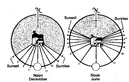
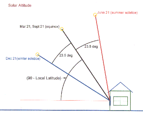
Diagrams showing sunrise/sunset positions for the summer and winter
solstices, and the suns altitude at the solstices and equinoxes.
Obstacle Survey
The obstacle survey lets you check for blockage of the sun by building,
trees, hills etc.
You will need the following
- A Sun Chart for your area (see below)
- A device to measure elevation and azimuth angles (see below)
Sun Charts are available here:
http://solardat.uoregon.edu/SunChartProgram.html . Just enter your zip
code, download the pdf version of the Sun Chart, and print it out. The Sun
Chart shows the position (azimuth and elevation) of the sun for every minute of
the year -- all on one piece of paper! It is worth spending a few minutes
studying the Sun Chart, and understanding how it works. It's a great way to
check your understanding of the movement of the sun in the sky throughout the
day and the year.
You will also need to make gages to measure the sun azimuth and elevation
angles.
Make the Elevation gage
- Paste one copy onto a piece of cardboard.
- Trim the cardboard along the Site Line (you will site along this
edge for elevation measurements)
- Put a small nail through the center of the Reference Circle where all the
lines meet
- Tie one end of a light string to the nail, and the other end to any
small weight (e.g. a bolt or nut)
Make the Azimuth angle gage
- Paste the other copy onto another piece of cardboard.
- Find a thin, straight piece of wood (e.g. a wood pencil) and drill a small
hole near one end. You will site along this pointer to measure azimuth
angles.
- Put a small nail through the drilled hole, and then through the center of
the reference circle.
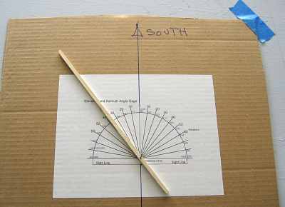
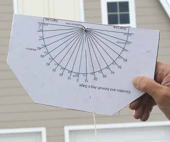
Elevation and azimuth gages in use.
Doing the Site Survey
Set up a reasonably level surface (e.g. a card table) about where your collector will be.
Tape the Azimuth angle gage to the table such that 180 on the blue azimuth
scale faces true south. Here are some ways to determine
where true south is.
Measure the azimuth and elevation angles for each of the high points along
your horizon. Start from northeast and work your way around through south
to the northwest. To measure the azimuth angle of a object,
site along the pointer that you attached to the azimuth gage, and move it until
it is lined up with the object. Then read the azimuth angle off the
azimuth gage where the pointer passes the azimuth angle number scale.
Measure the elevation angle for the same object by sighting along the Sight Line
on the Elevation Gage. Read the elevation angle where the string crosses
the elevation angle scale. Make sure that the string is not binding on the gage when you
make the reading. Mark the azimuth and elevation angles of each high
point on the Sun Chart as you go with a dot. Mark the position of the
horizon on your sun chart by drawing lines between the elevation points you
marked on the chart.
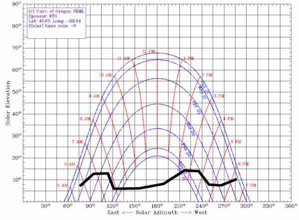
Sun chart with obstacle horizon marked.
Reading the Results
For most types of solar applications, you will be fine if you have 5 or 6 hours of
unblocked sun that is roughly centered around solar noon. If you have
blockages during this 6 hour period, you need to evaluate how long they are, and
at what times of year they occur.
If blockages are serious, then you can consider 1) moving the collector to a
better location, 2) trimming the obstacle (good for trees -- not so
good for buildings and mountains), or, 3)
aiming the collector such that it gets more unobstructed sun -- for example, if the sun is
good in the morning, but blocked in part of the afternoon, you could think about
aiming the collector a bit east of south in order to get more morning sun.
For solar space heating applications, you must have good sun during the
winter months (when the sun is the lowest and blockages are most likely). For water heating, some
blockage during mid-winter may be acceptable, since you would still get good
water heating the rest of the year.
Blockages caused by deciduous trees may be acceptable for solar applications
like space heating, in that the trees will let most of the light through when
the leaves are gone in the winter.
If you want a quantitative look at how much a particular obstacle might hurt,
run the Radiation On Collector tool.
Look at the hourly solar energy inputs, and see what percentage of the total
solar input for the day that the obstacle blocks.
Photovoltaic panels can be particularly sensitive to partial shading. Shading even a small part of a panel can significantly cut the panels output.
Also, bear in mind that trees grow.
An Alternate Approach
Another way to do the solar site survey is to build a simple model of your
house and of any obstacles that may block the sun using a computer graphic tool
that is capable of showing the how the sun will shine on the house or
collector at any time of day for the full year.
One very easy to use and free program for doing this is the SketchUp drawing
tool that is a free download at Google ...
more
info on SketchUP If you want to get an idea if this is the right
approach for you, try the 10 minute, 3 part tutorial that comes up when you
first run SketchUp -- part 2 or part 3 shows how to use the built in "sun" tool
to generate solar shadows on your model.
Personally, I think its nicer to get outdoors, and use the Sun Charts etc. as
described in the first part of this section, but the computer model does offer
some flexibility in moving things around and seeing the effect -- try both!
Gary 4/1/05
Updated 5/2/06