|
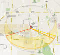
Solar Site Survey |
Solar Site Survey... |
 If
you are going to do a solar project, you need to do a Solar Site Survey to
make sure that your site gets enough sun during the right times of year to
make the project work. If
you are going to do a solar project, you need to do a Solar Site Survey to
make sure that your site gets enough sun during the right times of year to
make the project work.
This free and simple survey only takes an hour and is fun and educational.
Its a must do for any type of solar project! |
|
Skyview app to do solar shading surveys |
 The
free Skyview app is normally used to allow iPhones etc. to find stars in the
night sky, but it can also be used to do a first cut solar survey to find
obstacles that shade your solar collectors. The
free Skyview app is normally used to allow iPhones etc. to find stars in the
night sky, but it can also be used to do a first cut solar survey to find
obstacles that shade your solar collectors.
To use it, you make sure it is set to your location, then set the date and
time of interest, then select the sun object. Standing at your your
proposed collector location, pan across the horizon -- the path of the sun
will be projected on the screen so you can see when it is lower in the sky
than nearby trees, buildings etc. The logical first date
to start with would be Dec 21 (the winter Solstice) when the sun is lowest.
I tried this on my iPad, and it worked pretty well, but I would still do the
site survey listed just above rather than relying fully on Skyview -- it can
be a real disaster to get the shading wrong.
Thanks to David for finding this and sending it in. |
|
Solar Shading and Other Solar Tools for Android Phones... |
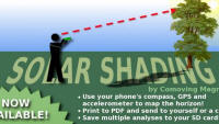 This
is reported to be a good set of tools to analyze your solar shading
situation for PV or solar thermal installations. This
is reported to be a good set of tools to analyze your solar shading
situation for PV or solar thermal installations.
Cost is $16.
Comments from Lawrence...
They also offer several other PV and electrical oriented tools for Android. |
| Sun
Tracker -- an iPhone application
http://www.imeasuresystems.com/
|
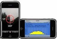 This
is a nice application from Andrew for the iPhone that allows you to do a
solar site survey using the iPhone's built in sensors for measuring
elevations and azimuth angles for the survey of the horizon. This
is a nice application from Andrew for the iPhone that allows you to do a
solar site survey using the iPhone's built in sensors for measuring
elevations and azimuth angles for the survey of the horizon.
While I've not had a chance to actually try it, it looks to me as though it
would do a good job.
Price is now up to $40 at the Apple App Store. |
| Solar Pathfinder
http://www.solarpathfinder.com/index
|
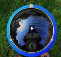 The
Solar Pathfinder has been around for many years, and is used by many solar
professionals to do solar site surveys. Basically its a glass dome,
and the reflection of the objects on the horizon is used to assess the
effect of objects on the horizon that would block the sun. Now offered
with software assistant. The
Solar Pathfinder has been around for many years, and is used by many solar
professionals to do solar site surveys. Basically its a glass dome,
and the reflection of the objects on the horizon is used to assess the
effect of objects on the horizon that would block the sun. Now offered
with software assistant.
Probably a bit of overkill for the DIYer building one or two projects. |
|
Bright Harvest Solar Survey
http://brightharvestsolar.com
|
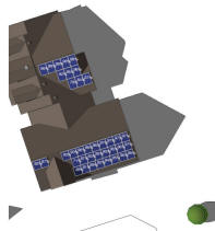 Bright
Harvest offers a new kind of solar survey. Based on aerial photos,
they make a digital model of your house and surrounding obstacles, and then
try various arrangements of collectors and estimate the shading for each. Bright
Harvest offers a new kind of solar survey. Based on aerial photos,
they make a digital model of your house and surrounding obstacles, and then
try various arrangements of collectors and estimate the shading for each.
They did a report for my house, and
here are my thoughts on it...
In a nutshell, the service is not inexpensive, but the report is impressive.
|
|
Effect of Collector
Orientation On Performance |
Effects of Tilt and Azimuth On
Annual Incident Solar Radiation For the United States Locations
Craig Christensen and Greg Barker
The full paper... (pdf)
|
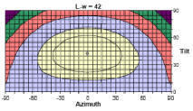 This
very good paper provides a very simple set of contour plots that show optimum
collector orientation, and the performance effect for deviations from
optimal. This
very good paper provides a very simple set of contour plots that show optimum
collector orientation, and the performance effect for deviations from
optimal.
Covers only the US, but the general relationships would be useful elsewhere.
Some limitations -- read the cautions in the paper. |
PVWatts
http://rredc.nrel.gov/solar/calculators/pvwatts/version1/ |
The very useful PVWatts tool can be used to work out the best orientation
for solar PV or thermal collectors at your location.
Simply try different tilt and azimuth angles until you maximize solar
irradiance on your panels over the desired time frame. |
|
Solar Position, Solar Radiation, Solar
Design Climatic Data |
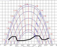
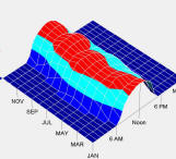
| Sun Charts
http://solardat.uoregon.edu/SunChartProgram.html
|
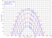 A Sun Chart for your area is a must have tool
to determine how much of the time sun will shine on your collectors.
See site survey for how it works. A Sun Chart for your area is a must have tool
to determine how much of the time sun will shine on your collectors.
See site survey for how it works. |
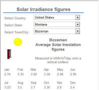
| GAISMA
http://www.gaisma.com/en/
|
 This
site gives sunset/sunrise times, as well as solar insolation, temperatures,
precip, ... This
site gives sunset/sunrise times, as well as solar insolation, temperatures,
precip, ...(thanks to WYWhiteWolf for suggesting this) |
Climate Consultant,
UCLA Energy Design Tools
http://www2.aud.ucla.edu/energy-design-tools/
|
 Climate
Consultant is one of the UCLA Energy Design Tools. Climate
Consultant is one of the UCLA Energy Design Tools.
It provides a variety of ways to visualize weather for a specific location.
Weather data files are available for hundreds of locations. This is a
brand new version, and is very easy to use.
"It graphically displays climate data in either metric or imperial units in
dozens of ways useful to architects including monthly bar charts, timetable
charts, and psychrometric charts, sun shading charts, and sun dial charts."
One of the most interesting charts is the Psychrometric chart
with overlays that show the design strategies (e.g. passive solar,
evaporative cooling, ..) will work for the location in question.
|
|
WeatherSpark
http://weatherspark.com/
|
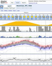 This
new site gives very nice summaries of weather for more than 4000 locations. This
new site gives very nice summaries of weather for more than 4000 locations.
The graphical presentation is very well done, and conveys a lot of
information in a very readable format. |
Weather Underground
www.wunderground.com |
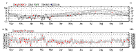 The
Weather Underground under the Local Weather -> History tab provides very
nice weather summaries for the time period you can enter. The
Weather Underground under the Local Weather -> History tab provides very
nice weather summaries for the time period you can enter. |
| Psychrometric Charts US units psychrometric chart...
SI units psychrohttp://www.uigi.com/UIGI_SI.PDFmetric chart...
Tutorial on using psychrometric chart...
|
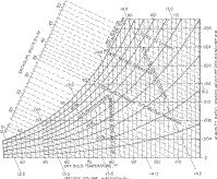 Psychrometric
Charts are very useful for working human comfort problems and air
conditioning schemes, and working out condensation problems. Psychrometric
Charts are very useful for working human comfort problems and air
conditioning schemes, and working out condensation problems.Climate
Consultant (just above) provides temperature/humidity data overlaid on a
Psychrometric Chart for many locations. |
|
Thermal Comfort Tool...
Hoyt Tyler, Schiavon Stefano, Moon Dustin, and Steinfeld Kyle,
2012, CBE Thermal Comfort Tool for ASHRAE-55.
Center for the Built Environment,
University of California Berkeley
|
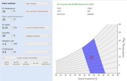 This
is a web based comfort calculator. It allows you to change air
temperature, humidity, air speed, ... and then shows where this condition
falls on the comfort chart. This
is a web based comfort calculator. It allows you to change air
temperature, humidity, air speed, ... and then shows where this condition
falls on the comfort chart.
(Thanks to Nick for finding this) |
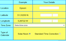
NOAA
Solar Calculator
http://www.esrl.noaa.gov/gmd/grad/solcalc/
|
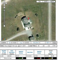 This
very handy calculator allows you to zero in on your house using satelite
images. You can then see how your house lines up with south, find
solar noon, sunrise and sunset times for any date. This
very handy calculator allows you to zero in on your house using satelite
images. You can then see how your house lines up with south, find
solar noon, sunrise and sunset times for any date. |
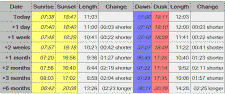
Solar Time to Local Time -- Solar
Noon,
NOAA
www.srrb.noaa.gov/highlights/sunrise/sunrise.html
|
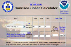 A
helpful calculator that gives sunrise, solar noon, and sunset in local time
for any location and any date. A
helpful calculator that gives sunrise, solar noon, and sunset in local time
for any location and any date.
Helpful in many situations, including finding true south at your location. |
SunCalc
www.suncalc.net |
 A
very simple and easy to use calculator to show sunrise, sunset, solar noon,
... at your location. A
very simple and easy to use calculator to show sunrise, sunset, solar noon,
... at your location. |
| Print Your
Solar Noon Calendar
http://www.solar-noon.com/
|
 Very
handy tool that prints out solar noon for every day of the year for your
exact location. Very
handy tool that prints out solar noon for every day of the year for your
exact location.
(thanks very much to Bill for suggesting this)
|
| Surface meteorology and Solar
Energy NASA
http://eosweb.larc.nasa.gov/cgi-bin/sse/sse.cgi?na+s01#s01
|
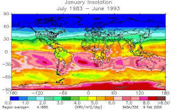 Solar radiation and solar geometry data from derived from satellite
observations. Provides data for anywhere in the world. Solar radiation and solar geometry data from derived from satellite
observations. Provides data for anywhere in the world.
Provides solar parameters for solar thermal, PV, solar cooking, etc.
based on 10 year history for your exact location. |
| Solar Radiation Tables... |
The tables provide solar radiation on a south facing collector at various tilt angles and for a range of latitudes. |
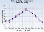
NOAA - Climate Data Online
|
NOAA - Climate Data Online
This free online service allows you to search a huge collection of climate
data for the US and the world, and then to download the data you select.
|
| More Solar Radiation and Weather
Data Sources NOAA
http://lwf.ncdc.noaa.gov/oa/ncdc.html
NOAA CLIM20 Weather Summaries by City
NOAA year to date degree days
NREL (and other) Solar Radiation and Climatic
Data
http://rredc.nrel.gov/solar/pubs/redbook/
Total and diffuse radiation or building surfaces:
Solar
Radiation Data Manual for Buildings
Typical Meteorological Year weather files
http://rredc.nrel.gov/solar/old_data/nsrdb/tmy2/ |
NOAA provides a variety of weather
related products and data. The CLIM20 product provides pretty detailed
historical weather summaries for many US towns. It includes
temperatures, precip, and heating and cooling degree days. Lots of
good data.
NOAA year to date degree days provides deg day totals for the current
year. Updated each week.
NREL Redbook:
Average weather conditions and solar radiation
of collectors at various orientations for many US cities. Based on 30
year weather records. Try downloading the pdf version for your state.
Can be used to roughly calculate gain for collectors.
NREL Bluebook: The Solar Radiation Manual for Buildings gives total and
diffuse radiation on S, N, E, W and horizontal surfaces.
This can be used as base data for many passive gain calculations.
TMY weather files give provide typical hour by hour weather files to
provide weather input for simulations. |
|
Climate Data
|
 One of the Sustainable By Design tools that provides a variety of climate data -- things like sunny days, heating degree days, precipatation, ... One of the Sustainable By Design tools that provides a variety of climate data -- things like sunny days, heating degree days, precipatation, ... |
Solar Electricity Handbook --
Irradiance Calculator
http://solarelectricityhandbook.com/solar-irradiance.html
Note that
PVWatts, which is a PV oriented calculator by NREL also provides solar
irradiance on the surface you specify, and this can be used as input for
solar thermal calculations in the same way. |
 This
is a very easy to use calculator that gives solar radiation levels for many
locations worldwide by month. It provides radiation levels for equator
facing surfaces, and allows you to pick from several tilt angles. This
is a very easy to use calculator that gives solar radiation levels for many
locations worldwide by month. It provides radiation levels for equator
facing surfaces, and allows you to pick from several tilt angles.
Output is in KWH/sqmeter -- 1 KWH/sqmeter = 317 BTU/sqft
Thanks to Andre for suggesting this |
| Clear Sky Charts
http://cleardarksky.com/csk/
|
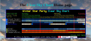 This
is really a tool for astronomers, but if you are a solar energy nut and you
are always obsessing over whether the next 48 hours are going to have any
good sun, this tool can be handy. This
is really a tool for astronomers, but if you are a solar energy nut and you
are always obsessing over whether the next 48 hours are going to have any
good sun, this tool can be handy.
It gives a cloud cover forecast by hour for about 48 hours for thousands of
locations. |
| The
Solar Spectrum... |
 Shows
the distribution of solar radiation energy by wavelength. Shows
the distribution of solar radiation energy by wavelength. |
Borst Engineering and Construction
Calculators
Many Calculators... |
Borst Engineering has a whole raft of calculators -- HVAC, solar position,
shading, and incident heat, water wheels, pipe sizing, ... |
|
Heating and Cooling
Degree Days |
| Energy CAP Free Degree-Day Weather
Tools
http://www.energycap.com/weather/
|
 A
nice set of free web tools that give heating and cooling degree day
information for 1200 locations. A
nice set of free web tools that give heating and cooling degree day
information for 1200 locations.
Provides historic, current, and even near term degree day forecasts.
Very easy to use.
Note that a default balance point temperature is 55F is used -- you
can change it to the more usual 65F if you wish. |
| Year to
Year Degree Day Comparisons
http://www.weatherdatadepot.com/dd.asp
(see: FREE Degree Day Report)
An example of how to make apples to
apples comparisons of fuel use in for two years ... |
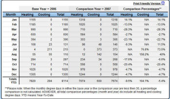 This
report provides month by month comparison of heating and cooling degree days
between two years you select. This
report provides month by month comparison of heating and cooling degree days
between two years you select.
This allows you to make apples to apples comparison of fuel use for two
years, and to see the actual effect of changes you made to reduce
energy use.
An example of how to make apples to apples
comparisons of fuel use in for two years ... |
| Degree
Days.net -- Worldwide Degree-Day Tool
http://www.degreedays.net/
|
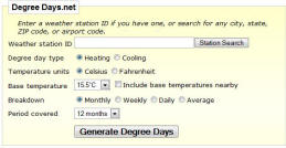 Nice
tool for heating or cooling degree-day summaries for locations around the
world. Nice
tool for heating or cooling degree-day summaries for locations around the
world.
The data comes from Weather Underground stations, so it may be easier to
find a location near you. |
| NCDC Degree-Day Maps
Heating and Cooling Degree Day Maps
Heating Degree Day Map of US (130K)
Cooling Degree Day Map of US (100K)
National Climatic Data Center
http://lwf.ncdc.noaa.gov/oa/ncdc.html |
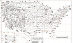 Heating
and cooling degree-day maps for the US. Heating
and cooling degree-day maps for the US. |
|
Window Shading and
Overhangs |
| Designing Shading Overhangs with
Google SketchUp
http://www.sketchup.com/
Example -- Using SketchUP to model sun
and shadows on a home...
|
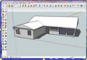 SketchUp
is a free 3D drawing tool from Google. In addition to being
easy to use as a general purpose drawing tool, it offers a
built in sun. SketchUp
is a free 3D drawing tool from Google. In addition to being
easy to use as a general purpose drawing tool, it offers a
built in sun.
You can easily draw a wall with a window and overhang (or a whole home),
and play the sun over it for various times of day and times of year.
Shading structures of all types can be modeled, including trees, solar
sails, shade walls, window fins, ...
Sun patterns inside the home are also shown.
It would be good for modeling sunspaces and greenhouses as well.
An example showing how to set it up for home ... |
Sustainable By Design Solar Tools
www.susdesign.com/tools.php
Several other useful tools listed on the same page. |
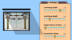 Some very well done (and free) tools for
designing overhangs, determining sun position, ... Some very well done (and free) tools for
designing overhangs, determining sun position, ...The overhang design
tool is very good, and is the best way to get a quick feel for how overhangs
work. |
|
Wind |
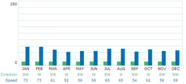
| Got Wind? --
How to use the Wind
Resource Atlas of the United States
|
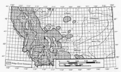 The
Wind Resource Atlas of the United States will give you a rough idea if you
are in a locations with wind potential --
here is how to use it. The
Wind Resource Atlas of the United States will give you a rough idea if you
are in a locations with wind potential --
here is how to use it. |
|
PV |
PVWatts -- A Performance Calculator for Grid-Connected PV Systems
From NREL
http://rredc.nrel.gov/solar/calculators/PVWATTS/
This is a really useful tool. |
An easy calculator you can use to find out how
much power you will get from a PV installation in your area.
It calculates PV system performance based on hour by hour records for sun in
your area.Version 1 is very easy to use, and works worldwide.
Version 2 allows more detailed inputs, but seems rather complex and puzzling
at times to me. |
